CONUCO · Nassau, The Bahamas

Innovation from land to sea.

CONUCO brings proven, field-tested technology to The Bahamas — precision agriculture, water resilience, coastal monitoring, and workforce training. From farm soil to coral reefs, we turn what already works into shared local prosperity.

The better off we all are, the better off we all are.

0% Field-validated water savings
0% Crop yield increase
0% Less manual research time
0 Families served by the academy model

The replication model

Don't reinvent. Replicate what already works.

Rather than building new technology from the ground up, CONUCO takes capability and field methods already proven elsewhere and adapts each one for the Bahamian setting — island water, soils, coastlines, and the needs of local businesses and communities. The result is a replication map: proven, local, and built for The Bahamas.

01

Proven capability

Start with a tool that already delivers measurable results — in agriculture, water, research, or automation.

02

Bahamian adaptation

Tune it to local conditions — island water, soils, coastlines, and the realities of Bahamian businesses and communities.

03

Local delivery

CONUCO leads on the ground in The Bahamas, drawing on the proven methods and foundation of its sister company.

04

Shared outcome

Every deployment is measured by what it raises locally — food, water, coastal health, jobs, and talent.

What we do

Four programs, one resilience story.

CONUCO runs four connected programs — small business, research, the blue economy, and people. Each pairs proven capability with local delivery to move a Bahamian national priority forward.

Where we start

Small Business

Helping Bahamian MSMEs adopt proven technology

A technology-adoption cohort: CONUCO and partner small businesses adopt proven technology to grow and operate more efficiently.

  • Business automation
  • Procurement intelligence
  • Precision agriculture
Research & academic

Research

Field data and AI for university research

Partner with a university faculty lead on a localized study — drone-collected field data analyzed at scale by AI — producing rigorous findings on a real Bahamian challenge.

  • AI research engine
  • Aerial sensing
  • Precision agriculture
Coastal & marine

Blue Economy

Drone survey and water monitoring for the coast

A coastal monitoring pilot using aerial survey and water sensing to build a repeatable record of shoreline and reef-adjacent conditions, with AI synthesizing the data into reports conservation teams can use.

  • Aerial sensing
  • Water monitoring
  • AI analysis
Workforce & community

People

Training the next generation of Bahamian technologists

A Bahamian leadership and workforce academy in technology and sustainable agriculture — hands-on training tied to real pathways, feeding graduates into the small-business, research, and conservation work.

  • Workforce academy
  • Purposeful economics

The capability portfolio

Capability proven in the field — built for The Bahamas.

Each capability has a track record that transfers cleanly to a Bahamian setting. The same sensing and analytics that protect a crop extend naturally into the coastal zone.

🌱

Precision Agriculture & Water

Smart irrigation & soil intelligence

Turns soil, irrigation, and field data into decisions — field-validated for up to 58% water savings and 23% higher yields. For an island where fresh water is scarce, this is foundational.

Water & soil intelligence

🚁

Drone Aerial Sensing

Aerial survey & environmental mapping

Captures aerial imagery and sensor data for crop health, land use, and environmental survey. The same flights that scan farmland can map mangroves, shorelines, and reef-adjacent zones.

Agriculture to coastline

🧠

AI Research Engine

Grounded retrieval & analysis

Agentic retrieval and reasoning that lets researchers and institutions query large bodies of documents and data and get grounded answers fast — the engine behind rigorous research.

Grounded AI analysis

🏛️

Procurement Intelligence

Win public-sector work

Helps small businesses find and pursue government work, cutting manual research time by up to 70% so local firms can compete for public contracts on a level field.

Compete for public contracts

⚙️

Business Automation

Remove manual back-office work

Automates repetitive manual tasks across small-business operations — freeing owners to focus on growth instead of paperwork.

Workflow automation

🎓

Workforce Academy

Training tied to real pathways

A proven workforce and education model that has served more than 300 families — hands-on training tied to real career pathways in technology and agriculture.

Training to opportunity

The blue economy play

From the field to the shoreline.

The Bahamian maritime environment is unlike anywhere else — and the capability built for precision agriculture, sensing an environment and turning readings into decisions, extends naturally into the coastal zone.

CONUCO's coastal monitoring pilot uses aerial survey and water sensing to build a repeatable record of shoreline and reef-adjacent conditions, with AI synthesizing the data into reports conservation teams can act on. One resilience story, joining land and sea.

  • Aerial mapping of mangroves, shorelines, and reef-adjacent waters
  • Repeatable water-quality and coastal-health records over time
  • AI-synthesized reporting for conservation and research teams
  • Science-based metrics for reef-positive conservation and reporting
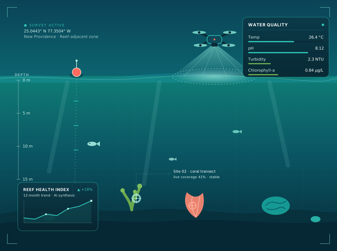
Scientific illustration of a survey drone scanning a coral reef, with water-quality telemetry, depth profiling, and reef-health monitoring data.
Aerial survey + reef-adjacent water-quality sensing, synthesized by AI into a repeatable scientific record.
Live coastal conditions Nassau, The Bahamas
°C Sea-surface temp
m Wave height
km/h Wind speed
°C Air temp

Fetching live data… · Source: Open-Meteo

Replication roadmap

A phased rollout — fastest wins first.

We start with the fastest path to a first pilot, then build out. Each phase builds proof and broadens reach.

  1. Phase 1

    Foundation

    Confirm CONUCO as the Bahamian anchor and deploy one proven capability inside CONUCO as the first reference adoption.

  2. Phase 2

    Prove

    Document results from the CONUCO adoption as a local case study, recruit a first cohort of small businesses, and open a university faculty conversation for a research pilot.

  3. Phase 3

    Expand

    Launch the coastal monitoring pilot, advance a university research collaboration, and stand up the leadership and workforce academy.

  4. Phase 4

    Connect

    Link academy graduates into small-business, research, and conservation work; publish combined results under one Bahamian resilience story; expand into a second cohort and new sites.

Roles & partnership

Local delivery, proven methods.

CONUCO

The Bahamian anchor

An independent, Bahamian-owned enterprise. CONUCO holds local relationships and ground operations, runs the first reference deployment, coordinates field logistics, and recruits the business cohort and academy trainees.

Rashayne Rahming

Founder & local lead

Single point of contact for CONUCO's programs and partners — leading community recruitment, field-logistics coordination, and relationships across government, universities, and conservation partners.

Meet our founder →

Avid Solutions International

Sister company & foundation

An established agri-technology and AI firm — and CONUCO's sister company, not its parent. Avid gives CONUCO a strong technical foundation from day one: proven platforms, field methods, training, and operating playbooks that CONUCO adapts for The Bahamas.

Let's bring it home to The Bahamas.

Whether you're a funder, a faculty partner, a small business, or a future trainee — there's a place for you in this work. Reach out to start a conversation.